SMOCK- Spatial Modelling for mapping COVID-19 risk
About
The lack of knowledge about the SARS-Cov-2 combined with a global pandemic crisis, caused by the rapid spread of COVID-19 disease makes the need for the development of tools suited to monitor and evaluate infection risk dynamics. This is valuable information for health authorities for containing and mitigating the spread of the COVID-19 pandemic. With this in mind, this project gathers a multidisciplinary team of experts in geo-spatial data sciences, epidemiology, public health, computer sciences and decision sciences in health to develop a set of tools to model the spatial and temporal evolution of the risk of infection to support decision-making of health and civil protection authorities.
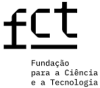
These tools will be coupled in a web-based dashboard where information from various sources and models are represented in an appropriate way for crisis management in terms of health, population safety and logistics, and where methods and data in use are communicated according to the best practices in information visualization. The information to be delivered in this project will be centered on COVID-19 risk maps with high spatial resolution for the mainland Portuguese territory, to be developed under a geostatistical modelling framework. Moreover, geostatistical simulation algorithms will be used to provide a measure of spatial uncertainty attached to the predicted risks. Here it must be underlined the relevance of quantifying spatial uncertainty shown by COVID-19 risks maps to support decision-making (e.g., to set local lockdowns). The project will use data concerning the number of positive tests for COVID-19 as provided by the Direcção Geral da Saúde (Portuguese Directorate-General for Health). Other auxiliary information such as mobility, socio-demographic and economic factors will be included in the models, improving not only the accuracy of predicted risks but also reducing their spatial uncertainty. The project will demonstrate the benefits of using geostatistical models to assess the effectiveness of the measures to prevent virus propagation during all stages of the pandemic, to balance demand and supply of medical resources required to control the disease and learn lessons ahead of any possible second or third epidemic waves, while developing a vaccine.
Coordinator/Local PI